Bursa Province
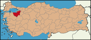
Bursa is a province in western Turkey, along the Sea of Marmara. Its adjacent provinces are Balıkesir to the west, Kütahya to the south, Bilecik and Sakarya to the east, Kocaeli to the northeast and Yalova to the north. The province has an area of 11,043 km2 and a population of 2,413,971 (2006 est). It was 2,125,140 according to the 2000 census. In 1990 it had a population of 1,603,137. The traffic code is 16. The city of Bursa was the capital of the Ottoman State until the conquest of Edirne. Most part of the province remained in Marmara Region except districts of Büyükorhan, Harmancık, Keles and Orhaneli, who are bounded to Aegean Region.
Districts
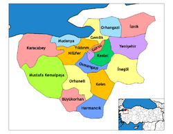
Bursa province is divided into 17 districts (capital district in bold):
- Büyükorhan
- Gemlik
- Gürsu
- Harmancık
- İnegöl
- İznik
- Karacabey
- Keles
- Kestel
- Mudanya
- Mustafakemalpaşa
- Nilüfer
- Orhaneli
- Orhangazi
- Osmangazi
- Yenişehir
- Yıldırım
See also
External links